This post may contain affiliate links. When you purchase something through these links, I receive a small commission that helps me create this blog’s content. There’s no extra cost to you.Read my privacy policy to learn more.
Find the Perfect Hike for your Minnesota Winter Getaway
Enjoying Minnesota’s winter wonderland can be as easy as pulling on your snow boots and heading out for a hike.
As someone born and raised in northern Minnesota, I’m a firm believer in getting outside year-round, regardless of what the thermometer says! But sometimes I don’t want to faff about with skis, snowshoes, or skates, which is why I’m a big fan of winter hiking. A little snow and cold isn’t going to stop me from experiencing my favorite North Shore hiking trails.
Over my many winters along Lake Superior’s North Shore, I’ve accumulated quite the list of favorite winter hikes. You’ll find these hikes in state parks, along sections of the Superior Hiking Trail, and the edge of the Boundary Waters Canoe Area Wilderness. Some of these hikes, like the Kadunce River waterfall walk, are completely inaccessible until a stretch of subzero temps in the deep winter.
Whether you’re staying in Duluth, Two Harbors, Grand Marais, or up the Gunflint Trail, here’s where I’d take you winter hiking! You’ll soon see that the seasonality of hiking in northern Minnesota is simply a state of mind.
Be sure to read until the very end for my recommendations for winter hiking gear, some safety tips and other North Shore winter FAQs, suggestions for where to stay, and even a hike to check out if your winter getaway takes you over the Canadian border.
Why trust me with your Minnesota winter hiking? I’m a lifelong resident of northern Minnesota who has spend her entire adulthood working in outdoor recreation. I own a Boundary Waters canoe outfitters on the Gunflint Trail and spend my free time exploring the Superior National Forest and Lake Superior’s North Shore.
Seven Favorite Minnesota Winter Hikes
1. Ogantz Trail at Jay Cooke State Park
Ogantz Trail in Jay Cooke State Park is the perfect spot to stretch your legs after a couple hours in the car if you’re making the drive north from the Twin Cities. Pick up the trail in the Oldenburg Point Picnic Area, just a mile up MN Highway 210 from the park’s infamous swinging bridge.
This 1.8 mile loop trail shares its name with Jay Cooke’s childhood friend Chief Ogontz of the Wyandot Tribe in Ohio. The trail starts with two overlooks of the dramatic St. Louis River gorge. If you look carefully, you’ll spy the Swinging Bridge up the river. At the second overlook, several informational plaques discuss the development of Jay Cooke State Park. In winter, you’ll probably need to remove snow if you want to read them!
The trail meanders downhill through the hardwood forest. After briefly leveling off, the trail then loops around to climb back uphill to the parking area. Although you may see some skiers on the trail, Ogantz Trail is designated for snowshoers and hikers. The trail isn’t difficult, but the final hill climb will certainly get your heart pumping. If you love a trail that combines history, vistas, and peaceful woodland wanders, you’ll love the Ogantz Trail.
About the Ogantz Trail
Access point: Jay Cooke State Park on Minnesota Highway 210 between the towns of Carlton and Fond Du Lac Parking: Oldenburg Point Picnic Area Trail style: Loop Length: 1.8 miles Difficulty: Easy Notes: You need a Minnesota State Park pass to park at Oldenburg Point.
2. Split Rock River Trail
Sure, you’ve heard of Split Rock Lighthouse, which is basically the poster child of the North Shore, but did you know that the “Split Rock” in the lighthouse’s name doesn’t actually referred to the cliff the lighthouse perches on? I had no idea there was actually a “split rock” until I decided to hike up the Split Rock River one random January afternoon.
It’s not definitively known if the river and lighthouse are named for the two large glacial erratic rocks located about two miles up the river’s bank. Regardless of where the name came from, the two rocks are an impressive spectacle well worth the two-mile one way hike up and down rolling hills along the Split Rock River banks.
While this spur trail of the Superior Hiking Trail is perhaps over-loved in the gentler seasons, it doesn’t appear to be a super popular winter hike. Many people wait until the river freezes hard enough to ski up the river to the Split Rock. We opted for the security of the river bank and thoroughly enjoy our hike through impressive cedar trees with some nice river views.
About the Split Rock River Trail: Access point: This trail starts right on the north side of Highway 61, about 17 miles north of Two Harbors. Parking: Park in the MN DOT Split Rock River wayside rest, located at 2437 MN-61, Two Harbors. Trail style: Out and back . . . maybe loop? Length: 4 miles round trip Difficulty: Easy, but bring snowshoes. The trail to the actual Split Rock is farther than many casual wayside rest hikers will go, so you may lose a packed trail about a mile in when people decide to turn around. Notes: This trail technically makes a loop, but that loop is contigent on a river crossing. Once upon a time there was a bridge where you’d start to loop back down the east side of Split Rock River, but long story short, it is no more.
Maybe you can find a spot with thick enough ice to ford the river, but I wasn’t willing to risk wet feet two miles from my car in subzero weather. We were happy with an out and back hike.
3. Day Hill at Split Rock Lighthouse State Park
About the Day Hill Trail
If you already have a Minnesota State Parks pass on your vehicle’s windshield, there’s absolutely no excuse for not doing this short, rewarding loop hike located in the heart of Split Rock Lighthouse State Park. This is the perfect leg-stretcher hike on the way up the North Shore, whether you’re headed to Grand Marais, Thunder Bay, or just day trip up to see favorite North Shore, MN stops.
Start your hike with a short jaunt on Pebble Beach where you’ll enjoy views of Split Rock Lighthouse and Little Two Harbors. The trail is very well signed with the quintessential brown and gold wooden Minnesota state park signs. Just don’t turn north too early, or you’ll end up in the park’s cart-in campsites on the wrong side of a ravine to access Day Hill.
The most interesting landmark along this hike is a large stone fireplace at the tippy top of Day Hill. It’s said that Frank Day, a Duluth businessman, constructed this fireplace when he started building a house here, then abandoned the project. It’s easy to see why someone would be drawn to this building spot; the Lake Superior views are spectacular.
This definitely isn’t a difficult hike, even with the hike up Day Hill. Just use caution on Bob’s Stairway – an elaborate wooden walkway on the south side of Day Hill that you’ll need to traverse to make the loop back to your vehicle. While it was smooth sailing on the steps in late April when I hiked the trail (yes, it’s still winter in northern Minnesota at the end of April), I imagine the steps can get pretty treacherous with ice and snow pack.
Access point: In Split Rock Lighthouse State Park, located on the right hand side of U.S. Highway 61, 20 miles north of Two Harbors. Parking: Take the first right (towards the cart-in campsites) once you pass the Split Rock Lighthouse Park Office and park at the parking lot at the very end of this road. Trail style: Loop Length: 2 miles Difficulty: Easy Notes: You need a Minnesota State Parks pass to park for this hike. A big bonus of this hike is that the trailhead has ample parking and access to both latrines and flush toilets.
4. Shovel Point at Tettegouche State Park
This very easy trail located right behind the Tettegouche State Park visitor center and rest area frankly has more absolutely jaw-dropping views than a trail of its short length deserves. Winter makes the trail particularly spectacular. Enjoy gazing out over ice-covered Lake Superior bays and cliffs.
An easy .6 mile hike one way takes you to the end of Shovel Point, a spit of rhyolite rock that sticks out .2 miles into Lake Superior. Along the way, you’ll spy Palisade Head, access a beach, and peer up and down Lake Superior’s North Shore. After you’ve enjoyed exploring the clifftop, be sure to hike to the mouth of Baptism River so you can get a view of Shovel Point itself.
Because of its short, accessible nature, this trail is always pretty packed down and easy to walk on. However, that compacted snow can turn to ice on warm, sunny winter days. You might prefer wearing ice cleats to navigate slick spots on the hills and staircases. And remember, always exercise caution around cliff edges. Shovel Point is 656’ at its highest point and that’s a long way down!
About the Shovel Point Trail
Access point: Tettegouche State Park, located on the right hand side of U.S. Highway 61, five miles north of Silver Bay Parking: Access from Tettegouche State Park Visitor Center Trail style: Out and back Length: 1.2 miles round trip Difficulty: Easy Notes: You don’t need a state park permit if you park at the visitor center, but consider buying on anyway to support Minnesota State Parks.
5. Moss Lake Trail on the Gunflint Trail
No one ever seems to talk about the Moss Lake Trail in the mid-Trail area of the Gunflint Trail and I’m here to change that. Developed in the mid 2010s without fanfare, this nice woodland trail runs the entire length of Moss Lake’s south shore. The trail features one spectacular north-facing overlook of Moss Lake and the Boundary Waters beyond, as well as several “peekaboo” vistas through the forest.
If you have a hiking partner and two cars, you can make a nice four-mile through-hike starting either at the Caribou Rock Trail or Moss Lake portage and ending on the South Lake Trail. This route lends itself best to a late fall or early winter hike. Since the trail receives very little use, it’s a safe assumption that you’ll be breaking trail and as the winter wears on, the snow (obviously) just gets deeper and deeper.
However, if you opt to tackle the Moss Lake Trail in deep winter, you can turn this moderate hike into a nice six-mile loop. Just hike the trail westbound until you intersect with Moss/Birch Lake portage, then turn around and head east straight across the frozen lake. Return to your car via the Moss Lake portage to the Hungry Jack Lake Road. Just remember that you’ll definitely need snowshoes to make the trek across Moss Lake.
About the Moss Lake Trail:
Access point: Located down the Hungry Jack Lake Road, Cook County Highway 21, approximately 32 miles up the Gunflint Trail outside of Grand Marais Parking: Access from either the Moss Lake portage parking lot or the Caribou Rock Trail. Trail style: A thru-hike with two vehicles, out and back, or a loop in winter Length: 4 – 6 miles depending on which route you choose Difficulty: Moderate Notes: This trail isn’t well known and many Gunflint Trail hiking trail publications don’t mention it. If you’re a Gaia app user, it does show up on that map.
6. Kadunce River Hike
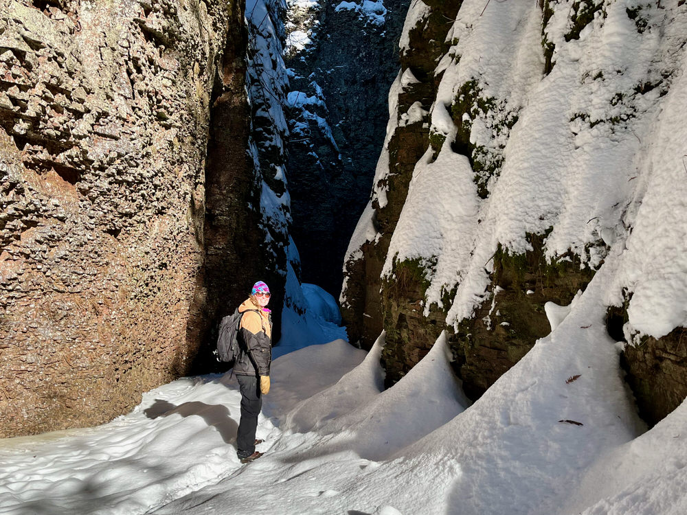
I think the Kadunce River Hike is the most magical winter hike on Minnesota’s North Shore, but it can be intimidating if you’ve never done it before. Because you’re actually hiking up a frozen river, the margin of error is a little higher than on your typical tromp through the woods.
For this hike, you’ll follow the Kadunce River about .9 miles north. You’ll access the river right at the start of the Superior Hiking Trail spur trail that runs up the east side of the river. From there, scramble up three waterfalls, hike through a slot canyon, and tour the canyon’s cliffs and alcoves. Yes, it’s just as enchanting as it sounds.
Depending on ice conditions, you may be able to the hike the river all the way to where it connects with Superior Hiking Trail spur trail. When I did the trail in January, the ice on the last .10 mile of the river looked pretty sketchy, so we scrambled up a steep cliff to rejoin the spur trail and used the spur trail to return to our cars.
If you don’t know how to judge ice conditions, simply stick to the established path. This is a pretty popular hike, so if you don’t see any tracks, the ice probably isn’t safe. This isn’t a trail to go rogue on. Wet feet in 0 degrees are no joke. Make sure you have dry socks and shoes waiting in your car, just in case.
About the Kadunce River Hike:
Access point: Access the river via the Superior Hiking Trail spur trail on the north side of Highway 61 on the east side of Colvill, about 10 miles north of Grand Marais. You’ll see a user-developed path down to the river through the snow. Parking: Park at the Kadunce Wayside Rest on the southside of U.S. Highway 61. (The highway signs spell river as “Kodonce.”) Trail style: Loop: go north on the river, then return to your car via the Superior Hiking Trail spur trail. Length: 1.8 miles round trip Difficulty: Moderate Notes:You can only hike up the river in deep winter and remember, no ice is ever “safe.” By late February or early March, the increased daylight starts eroding the river ice. Consult with a local (just ask your barista when you pick up your morning coffee!) before heading out to make sure conditions are safe.
7. High Falls at Grand Portage State Park
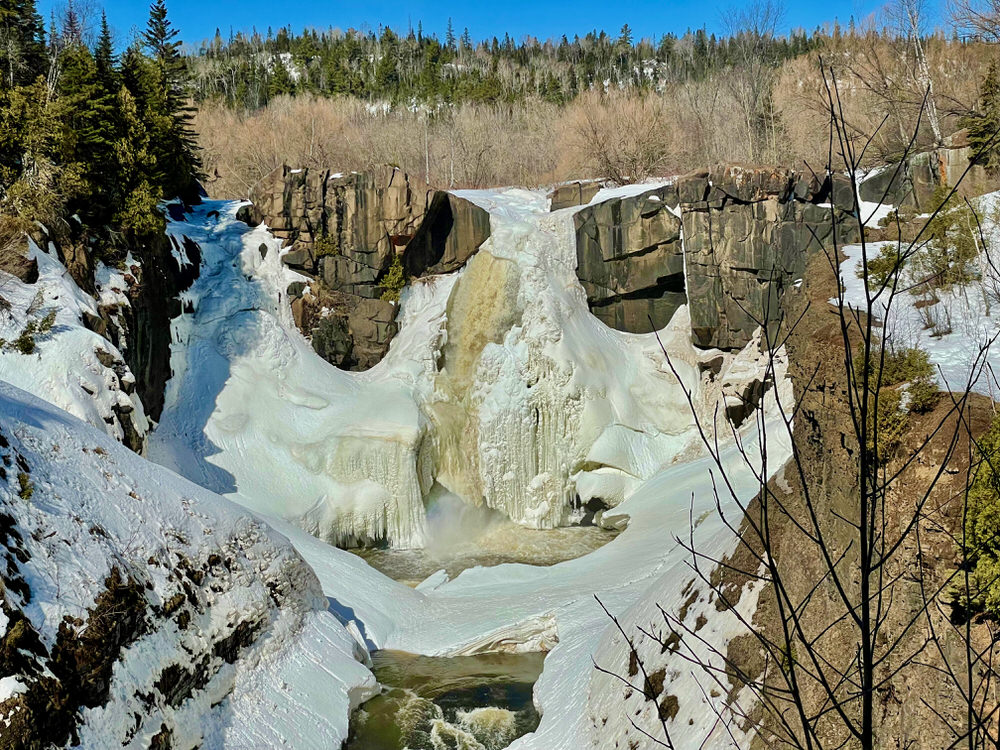
High Falls at Grand Portage State Park deserves a visit in all seasons. Although the tallest waterfall in Minnesota is truly at its finest during the winter melt in late April or early May, it’s worth visiting in the frozen months to see the 120’ drop sporting an ice cap. A quick .6 mile hike from the visitor center gets you to three observation platforms. The first platform gives you a bird’s eye view of the falls. Be sure to hike down to the lower ones to get the quintessential shot of the waterfall straight on.
In warm weather months, the trail to High Falls is ADA accessible. Although crews do their best in the winter to keep the paved path clear, I’d be hesitant to take a wheelchair up the path; it can be pretty icy in spots. When we went in mid-March, the path was clear enough to hike just in boots as long as you skipped around a little bit to avoid icy patches. Still, considering the easy trail and short distance, this is really more of a leg stretcher than an actual hike.
If you decide to turn it into a real hike, head up to Middle Falls another 1.5 miles up the river. You’ll definitely need snowshoes if you decide to continue on the trail past High Falls. Whatever course you decide on, don’t forget to wave to Canada on the other side of the Pigeon River!
About the High Falls Hike:
Access point: Pick up the trail behind the Grand Portage State Park visitor center Parking: Amble parking in front of the visitor center Trail style: Out and back Length: 1.2 miles round trip, with the option to go farther if you decide to continue up the path towards Middle Falls Difficulty: Easy, but watch for ice Notes: The state park visitor center doubles as a wayside rest so you don’t need a state park pass. If it’s open, plan to spend a little time with the visitor center exhibits.
Bonus hike: Sea Lion Trail in Sleeping Giant Provincial Park
Don’t let a little hiccup like an international border stop your North Shore winter hiking adventures! Back your passport and headed into northern Ontario for some epic views and hikes.
Sleeping Giant Provincial Park on the Sibley Peninsula about an hour northeast of Thunder Bay is beautiful winter destination. While the popular hikes to the top of the Sleeping Giant cliff formation become inaccessible with the winter snows, a short .8 mile hike takes you to the Sea Lion rock formation along the Lake Superior shoreline.
This striking sea arch off the southern tip of the Sibley Peninsula once resembled a lion with a full mane. Over time, the lion face has eroded away, but I still think – with a little imagination –you can still see the lion!
About the Sea Lion Hike:
Access point: Kabeyun Trail Head Parking: Large parking lot at trail head Trail style: Out and back Length: 1.4 miles round trip Difficulty: Easy Notes: Make sure you purchase your provincial park pass online before driving out onto the Sibley Peninsula where cell service is quite spotty.
Favorite Winter Hiking Gear
Clothing
It’s imperative that you dress in a way that will allow you to endure subzero temps, gusty winds, and all manners of precipitation. Remember to “dress like an onion” with lots of loose layers. Here’s my favorite winter apparel:
Winter boots – Forget hiking boots, you need bonafide winter boots for traction and warm. I love my Schnee’s Pac Boots. My mom swears by her Icebugs. Tip: Add insole inserts for extra support!
I’ve hiked all the trails described in this post in winter without snowshoes. Since these trails are popular and well traveled all year, the hikers before you will have probably created a nice compacted trail to cruise down. But even if it hasn’t snowed recently, it never hurts to throw snowshoes in your car just in case trail conditions are squirrelier than expected.
While I personally go to great lengths to avoid wearing snowshoes, they’re a good idea on hikes that include ice crossings because they spread out your body weight.
What about hiking poles?
I’ve never carried hiking poles (even on my long distance walks!) but they’d certainly help with stability in slippery conditions. They’d also come in handy if you need to test ice thickness.
How do I stay warm?
Dress in layers, but remember that more doesn’t necessarily mean warmer. Only your base layer should be skintight. Make sure your clothing is loose enough to create warm pockets of air around your body, especially your feet. You should be able to move freely without anything tugging or feeling tight.
There’s a reason we all wear ridiculously large hats and boots up north– that trapped warm air around our body keeps us toasty warm from head to toe. Once you learn to dress properly, you really won’t need hand warmers or heated jackets – honest!
How to have a safe cold season hike
Store your water bottle upside. Ice forms from the top down. When you want a drink, just flip your water bottle for an ice-free sip. Just make sure you have it sealed well so it doesn’t spill in your backpack!
Hike with a buddy when you can. There’s power in numbers + it’s just more fun!
Check the weather forecast before you go. You don’t want to be caught on the trail or driving home in a blizzard. If you’re doing a hike like the Kadunce River hike that’s dependent on certain ice conditions, make sure you talk to someone with firsthand knowledge of current conditions before embarking.
Always carry a well-stocked day pack. Often the difference between life and death is just a day pack filled with a couple lightweight items. Even though all hikes in this post are quite short, you still need to be prepared for an unexpected catastrophe, especially if you’re hiking alone.
Be cognizant to day length. Winter hiking is inherently slower than hiking in snow free conditions so you’ll want to make sure you have amble time to get back to the trailhead before sunset, especially in December and January.
Where To Stay
A cozy spot to enjoy a mug of hot cocoa and good book after your hike is mandatory for a perfect Minnesota winter getaway. These are some of my favorite spots that are conveniently close to the hikes in this post.
Trailhouse in Fond du Lac – I’ve actually stayed in this well-appointed vacation rental twice. With seven beds and five bedrooms, it’s perfect for a girls weekend and Jay Cooke State Park is just a short drive away.
Cove Point Lodge – Located just outside of Beaver Bay, Cove Point is well situated for hiking adventures up and down Lake Superior’s North Shore.
Lutsen Sea Villas – Right on Lake Superior in between Tofte and Lutsen, the Sea Villas are a great place to stay if you’re also planning to do some downhill skiing at Lutsen Mountains.
Thomsonite Inn – A quiet little inn located right on the shores of Lake Superior just a five-minute drive from downtown Grand Marais. They have a sauna on-site which sounds absolutely lovely after a day outside in the chill!
East Bay Suites – A solid hotel option right in downtown Grand Marais.
Timber and Tide Cabins –Sweet housekeeping cabins just east of Grand Marais on the Croftville Loop and up the Gunflint Trail.
Conclusion: Why you should hike in northern Minnesota in winter
Maybe you think tromping through snow in subzero temperatures sounds a little crazy. But I urge you not to wait for warm weather to explore northern Minnesota on foot. After all, you’re going to be waiting a while – winter up here can last six months!
You can only cozy up in front of the fire watching the 7’ of average snowfall pile up for so long. Luckily, winter in northern Minnesota is gorgeous and many of the hikes in this post simply aren’t as spectacular when the ice and snow have melted.
Contrary to popular belief, you don’t always need specialized outdoor equipment like skis or snowshoes to explore many favorite Minnesota trails in winter. The hiking options in this post typically just require winter boots and a parka.
A day on the trails is the best way I know to take advantage of winter’s fleeting daylight. So, pull on those boots and get hiking this winter. Your mental health will thank you!
Ada is a travel writer based in northern Minnesota. She’s spent two decades as a freelance writer. She’s lived in three countries and has visited all 50 states. In addition to traveling the world, she runs a Boundary Waters outfitters and helps people plan canoe trips and other outdoor adventures in northeastern Minnesota.
Christmas in Duluth is a magical time filled with events, markets, and more. Here’s everything to do in the Christmas City of the North this holiday season.
Spend one day in Oxford following in the footsteps of Tolkien, Pullman, and other English literary greats with this book lovers’ itinerary featuring colleges, walks, pubs, and other sites.
This definitive list of Harry Potter places to visit in the UK takes you to all corners of Great Britain, including London, Yorkshire, Wales, and Scotland.
Everything you need to know about walking the first half (downstream) of the Thames Path National Trail in southern England, including itinerary, tips, logistics, and points of interest.
I cover all the best things to do on the North Shore, MN including eats, hikes, shops, beaches, vistas, and mores. As a lifelong local, my guide ensures you have a Lake Superior road trip to remember.
This guide to the best things to do in New York at Christmas takes you to must-see trees, shows, markets, light displays, and more. Learn NYC Christmas trip tips, where to stay, and what to eat.